We would like to draw your attention to a new NHESS Invited Perspectives, which is now posted online. The paper focuses on lessons learned from our collective experiences with integrating hydrologic information into landslide forecasting models in different parts of the world, as well as ideas for future research needs and opportunities.
As with all EGUsphere articles, the paper is fully open access and free to read. We hope you will find it interesting and perhaps it can facilitate further discussions within the LandAware community. The preprint is open for discussion through June 24, and we would value your input whether formally or informally.
Slushflows are rapid mass movements of water-saturated snow. They release in gently sloping locations (<30°) and are hence not restricted to steep slopes. Slushflows are observed worldwide in areas with seasonal snow cover and pose a significant natural hazard in Norway. Hazard prediction and early warning are therefore crucial to prevent casualties and damage to infrastructure.
A regional early warning for slushflow hazard was established in Norway in 2013–2014 as the first of its kind in the world. It has been operational since then. Four main variables are central in the methodology used: ground conditions, snow properties, air temperature, and water supply to snow. Gridded forecasting model simulations in the decision-making tool Varsom Xgeo, real-time data from automatic stations, and field observations from the field are assessed. Based on data from historical slushflows, a water supply–snow depth by snow type ratio has been developed as an assessment tool. This approach can be implemented in other areas with slushflow hazard where the necessary input data are available.
Reference: Sund, M., Grønsten, H. A., and Seljesæter, S. Å.: A regional early warning for slushflow hazard, Nat. Hazards Earth Syst. Sci., 24, 1185–1201, https://doi.org/10.5194/nhess-24-1185-2024, 2024.
Shallow landslides are responsible for more than 50% of causalities due to landslides in northwestern Italy in the last century. The aim of the research study presented here is focused on understanding if and how climate change influences the occurrence and behavior of this landslide type. A total of 120 widespread shallow landslide events have been analyzed from 1960 to 2019, taking into account the spatial and time distribution in association with related rainfall historical data elaborated by the Optimal Interpolation (OI) model. Results underline that shallow landslide events’ number (aggregated per five-year intervals) is characterized by a weak trend consisting of a slight increase in the Alps and a more pronounced decrease in the hilly and Apennines environments. In addition, the trend of the annual accumulated rainfall average shows a weak drop in the winter season of about 9 mm in ten years. Moreover, the rainy days have generally decreased over the hills and Apennines, while in the Alps, only in the summer season, with a decreasing rate of about 1.5 days every ten years. The rainfall trends are in accordance with those of shallow landslide events, pointing out the close and direct dependence of the shallow landslide events on the rainfall regime variations. The results obtained were also used to validate the robustness of the performance of the Regional Shallow Landslide Early Warning System adopted in Piemonte over the investigated period, confirming the effectiveness of the trigger thresholds used for the entire historical series and for different geographical areas.
Reference: Tiranti D., Ronchi C. (2023) Climate Change Impacts on Shallow Landslide Events and on the Performance of the Regional Shallow Landslide Early Warning System of Piemonte (Northwestern Italy). GeoHazards 2023, 4(4), 475-496;
https://doi.org/10.3390/geohazards4040027
A new Special Issue entitled “Landslide Research: State of the Art and Innovations” in the GeoHazards journal is currently open for contributions. The Special Issue is guest-edited by Davide Tiranti. https://www.mdpi.com/journal/geohazards/special_issues/U728W8F9ZX The purpose of this Special Issue is to collect and group together quality scientific papers on these research fields and derived practical/operational applications. The topics related to the Special Issue therefore concern the innovative methodologies to achieve landslides identification, classification, characterization and hazard/risk evaluation through geomorphological field surveys and studies, remote sensing applications, GIS data mapping, processing and representation, the analysis of predisposing and triggering factors, landslide early warning systems implementation and the impact of current and future climate change scenarios on the evolution of these phenomena.
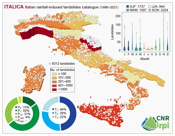
ITALICA, an extensive and accurate spatio-temporal catalogue of rainfall-induced landslides in Italy, is now online!
Over the last 15 years many researchers at CNR IRPI have been involved in compiling a catalogue called ITALICA (ITAlian rainfall-induced LandslIdes CAtalogue), which currently lists 6312 records with accurate information in space and time on rainfall-induced landslides that occurred on Italian territory between January 1996 and December 2021.
ITALICA provides the scientific community with a useful example of how to build accurate spatio-temporal catalogues elsewhere. The high accuracy of the catalogue’s data makes it particularly suitable for the prediction of rainfall-induced landsides (e.g. for defining rainfall thresholds to be implemented in landslide early warning systems).
Workshop #2 was about real-time monitoring strategies for risk management. Three different case studies were presented by Emanuele Intrieri (University of Florence), Armin Dachauer (WSL), Claudia Meisina (University of Pavia).
If you are interested to have access to the past workshops material (presentations, recordings, flyers) please send an email to luca.piciullo@ngi.no
New paper published on Natural Hazards journal on real-time monitoring and modelling: “A first step towards a IoT-based local early warning system for an unsaturated slope in Norway” https://link.springer.com/article/10.1007/s11069-022-05524-3
The paper describes a framework for a IoT-based local landslide early warning system (Lo-LEWS). Monitoring, modelling, forecasting and warning represent the main phases of the proposed framework. In this study, the first two phases have been applied to capture the hydrological behaviour of a natural unsaturated slope located adjacent to a railway track in Eastern Norway.
NEWS received from Davide Tiranti, Regional Agency for Environmental Protection of Piedmont region, Italy
New article “Wildfires Effect on Debris Flow Occurrence in Italian Western Alps: Preliminary Considerations to Refine Debris Flow Early Warnings System Criteria” published in the special issue of Geosciences journal on “Local and Territorial Landslide Early Warning Systems“
In this paper, two case studies in the Italian western Alps on the relationship between wildfires and debris flows occurrence have been analyzed to understand how to integrate this factor in the regional debris flow early warning system (DFEWS). To define these correlations, the authors conducted analyses to characterize changes in the conditions and behavior of catchments after wildfires. The Curve Number (CN) method was adopted to estimate hydrological variations before and after wildfires and identify the differences in catchments response to rainfall events, due to its simple applicability over a large number of catchments. Rainfall analyses, using both data from raingauges and weather radars to identify the actual distribution of precipitation intensity fields, were addressed. The case studies described have led to some interesting results, both regarding the understanding of the wildfires effects on debris flows triggering in small Alpine catchments and on the necessary technical and operational adjustments to improve the DFEWS performance in case of wildfire occurrence.
Reference: Tiranti D., Cremonini R., Sanmartino D. (2021) Wildfires Effect on Debris Flow Occurrence in Italian Western Alps: Preliminary Considerations to Refine Debris Flow Early Warnings System Criteria. Geosciences 11, 422. https://doi.org/10.3390/geosciences11100422
NEWS received from Paulo Hader – São Paulo State University (UNESP)
New article: Risk cross-referencing for landslide risk assessment at a municipal scale, by Paulo Hader and co-authors from São Paulo State University, Brazil
This recently published paper proposes a model for landslide risk assessment at the municipal scale, useful for early waninrg purposes. Three products, being rainfall thresholds, landslide susceptibility map and social vulnerability map were produced statistically. To couple them, the authors used a two-matrix approach, where in the first matrix the susceptibility map and the vulnerability map were crossed, constituting the socio-natural criterion; and in the second matrix, the rainfall thresholds were coupled to the socionatural criterion, allowing a real-time assessment. The authors found that the model offers easy adaptation and calibration once new data emerges, as well as being able to be integrated into a landslide early warning system to make explicit the areas of highest degree of loss, where interventions can be made in advance to reduce the risk in specific areas.
Reference: Hader, P.R.P., Reis, F.A.G.V. & Peixoto, A.S.P. (2021) Landslide risk assessment considering socionatural factors: methodology and application to Cubatão municipality, São Paulo, Brazil. Natural Hazards. https://doi.org/10.1007/s11069-021-04991-4
NEWS received from Adrian Wicki PhD StudentSwiss Federal Research Institute WSL Mountain Hydrology and Mass Movements Research Unit Zürcherstrasse 111 CH-8903 Birmensdorf
In a recently published article we assess the potential of simulated soil moisture for regional landslide early warning. For this study, soil moisture variation was simulated with a physically-based 1D soil water transfer model and forecasst goodness for landslides was assessed using a statistical landslide forecast model. In direct comparison with in-situ measured soil moisture we found that the overall representativeness for regional landslide occurence is high, however that it is particularly challenging to well characterize critical antecedent wetness conditions.
Wicki, A., Jansson, P.-E., Lehmann, P., Hauck, C., and Stähli, M.: Simulated or measured soil moisture: which one is adding more value to regional landslide early warning?, Hydrol. Earth Syst. Sci., 25, 4585–4610, https://doi.org/10.5194/hess-25-4585-2021, 2021.
A News/Kyoto Commitment article has been published today (online first) on the scientific journal “Landslides” to present the LandAware network to the many readers of the journal.
Calvello M, Devoli G, Freeborough K, Gariano SL; Guzzetti F, Kirschbaum D, Nakaya H, Robbins J, Stähli M (2020). LandAware: a new international network on Landslide Early Warning Systems. Landslides, online first. http://doi.org/10.1007/s10346-020-01548-7
Extracts from the article
Many recent international initiatives have been highlighting the importance of EWSs for disaster risk reduction purposes. [..] In response to these global initiatives, natural hazard experts working with EWSs around the world have recently founded programs and networks to promote international collaboration among members engaged in both surveillance of natural hazards and issuance of warnings to key stakeholders (authorities and public). Among them we can mention multi-hazard initiatives, such as the multi-stakeholder International Network for Multi-Hazard Early Warning Systems promoted by the World Meteorological Organization, as well as initiatives focusing on single natural hazards, such as the Intergovernmental Oceanographic Commission Tsunami Programme, the World Organization of Volcanic Observatories, the Global Seismographic Network of the IRIS consortium in the USA, and the European Avalanche Warning Services. Filling a gap in this global scenario, and in response to the abovementioned requests from the landslide risk scientific community, in July 2020 a multi-disciplinary international network of experts in LEWS was founded. The network is named “LandAware – the international network on Landslide Early Warning Systems”.
[..] upcoming activities of LandAware will always be, given the stated purposes of the network, in line with Kyoto Landslide Commitment 2020 priority action no. 1, which aims at promoting “the development of people-centered early warning technology for landslides with increased precision and reliable prediction both in time and location, especially in a changing climate context.”