Three days of interesting talks, discussions, exchanges, excursions and fun!
Many thanks to all the participants and the WSL organizers!
Three days of interesting talks, discussions, exchanges, excursions and fun!
Many thanks to all the participants and the WSL organizers!
NEWS received from
Catherine Pennington (British Geological Survey)
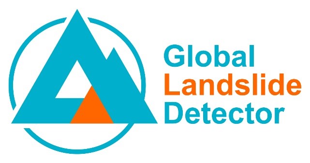
The British Geological Survey, the European-Mediterranean Seismological Centre and the Qatar Computing Research Institute have built a new Global Landslide Detector tool.
This machine learning tool extracts data automatically in 32 languages from social media in real-time, identifying landslides in photographs and placing them on the global map.
The tool is not intended to be used in isolation during a disaster scenario but could complement existing disaster workflows and provide new and timely data, taking into consideration the limitations described in the paper and data biases. It could also bring efficiency savings for data acquisition for landslide databases.
This first iteration of the tool involves more extensive model training experiments and a larger dataset than previous research.
Request for feedback:
The authors are asking the LandAware community to engage with the tool and feedback is requested on several elements including:
The paper: Pennington, C.V.L., Bossu, R., Ofli, F., Imran, M., Qazi, U.W., Roch, J. and Banks, V. (2022) A near-real-time global landslide incident reporting tool demonstrator using social media and artificial intelligence. International Journal of Disaster Risk Reduction, v 77, 103089, 14 pp. https://doi.org/10.1016/j.ijdrr.2022.103089
The tool: https://landslide-aidr.qcri.org/service.php
For any enquiries, please contact Catherine Pennington at the British Geological Survey
NEWS received from
Luca Piciullo (NGI Norway)
—–
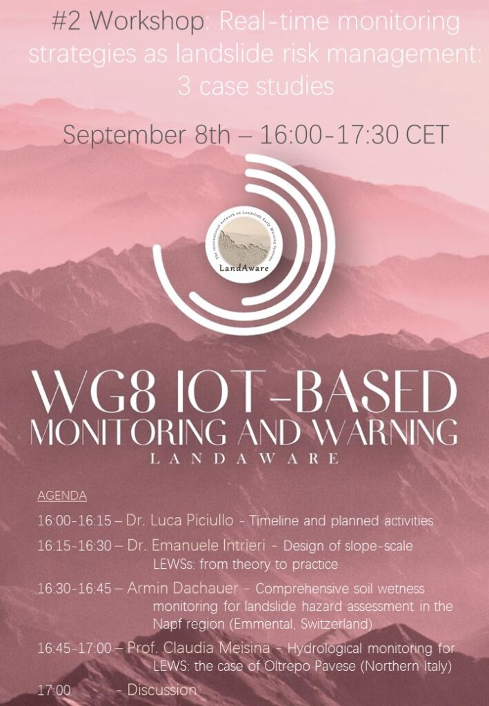
Second Workshop on Real-time monitoring strategies as landslide risk management for the IoT-based methods and analyses Working group
September 8 – 16:00 – 17:30 CET time
Agenda
16:00 – 16:15 – Dr. Luca Piciullo – Timeline and planned activities
16:15 – 16:30 – Prof. Emanuele Intrieri – Design of slope-scale LEWSs: from theory to practice
16:30 – 16:45 – Armin Dachauer – Comprehensive soil wetness monitoring for landslide hazard assessment in the Napf region (Emmental, Switzerland)
16:45 – 17:00 – Prof. Claudia Meisina – Hydrological monitoring for LEWS: the case of Oltrepo Pavese (Northern Italy)
17:00 – 17:30 – Discussion
Prof. Emanuele Intrieri is an Assisting Professor at the Earth Sciences Department at the University of Florence. His research is mainly devoted to landslides monitoring and forecasting, with particular reference to slope stability threatening cultural heritage and the characterization of historical and heritage stone buildings affected by detachments. He is author or co-author of more than 50 scientific publications in international journals and of a number of conference proceedings and book chapters. He took part in several national and international research projects and to civil protection emergencies as team member of the Centre of Competence of the Italian Civil Protection Department and of the UNESCO Chair on Prevention and sustainable management of geo-hydrological hazards.
Armin Dachauer received his master degree in Atmospheric and Climate Science at ETH Zurich. He is currently working as research assistant at the Swiss Federal Research Institute WSL (Birmensdorf, Switzerland), where he is responsible for soil wetness stations in Central Switzerland.
Prof. Claudia Meisina received her PhD in Earth Sciences from the University of Pavia (Italy). Currently is associate professor in Engineering Geology at the Department of Earth and Environmental Sciences of University of Pavia, where she leads the Laboratory of Engineering Geology and she is member of the PhD School of Earth and Environmental Sciences. She has been a post-doc at the BRGM in France. She received fellowships through Italian Foreign Affairs Ministry and Centre International pour la Formation et les Echange Géologiques. She is actually involved in Liquefact Horizon 2020 Project and in several projects about the role of land use in shallow landslide triggering.
__________________________
NEWS received from
Mirianna Budimir (Practical Action, SHEAR)
We are pleased to share some collaborative resources on landslide early warning systems co-produced by the Science for Humanitarian Emergencies and Resilience (SHEAR) programme and LandAware:
We hope you find these resources useful and encourage you to use them and share them with your networks.
As a reminder, these resources have been produced to complement existing SHEAR publications:
Related information and resources that are relevant from SHEAR can be found below:
For any questions, please contact mirianna.budimir@practicalaction.org.uk
NEWS received from
Mirianna Budimir (Practical Action, SHEAR)
A new publication on landslide forecasting was developed by one of the Impact and Influence projects under the FCDO and UKRI-NERC funded SHEAR programme. The title of the work is “Framework for implementation of a landslide early warning forecast model in developing countries: Challenges and lessons from SHEAR.“
Forecasting rainfall-induced landslides is a difficult yet important task that can provide time to take action to save lives, reduce economic losses and help to mitigate the impacts of landslides. The type, quality and accessibility of data directly constrain the choice of approach used for the landslide forecasting and its skill. However, in many landslide-prone countries, limited resources, and lack of investment lead to limited data availability and/or insufficient quality data for informed forecasts.
This paper collates understanding from SHEAR consortium members on key considerations for developing territorial (‘regional-scale’) landslide forecasts, particularly in developing country contexts.
The paper has been led by members from Consiglio Nazionale delle Ricerche, the British Geological Survey, the UK Met Office, and Practical Action Consulting International from the LANDSLIP project. The content of this publication has been greatly informed by discussions within LANDSLIP reflecting on project experiences through workshops within
the consortium and across the SHEAR programme.
NEWS received from
Michele Calvello (University of Salerno, Italy)
A PhD position in “Innovative monitoring and warning strategies for weather-induced landslides using IoT and Machine Learning” is offered at the University of Salerno, Italy. The deadline for applications is 14 July 2022.
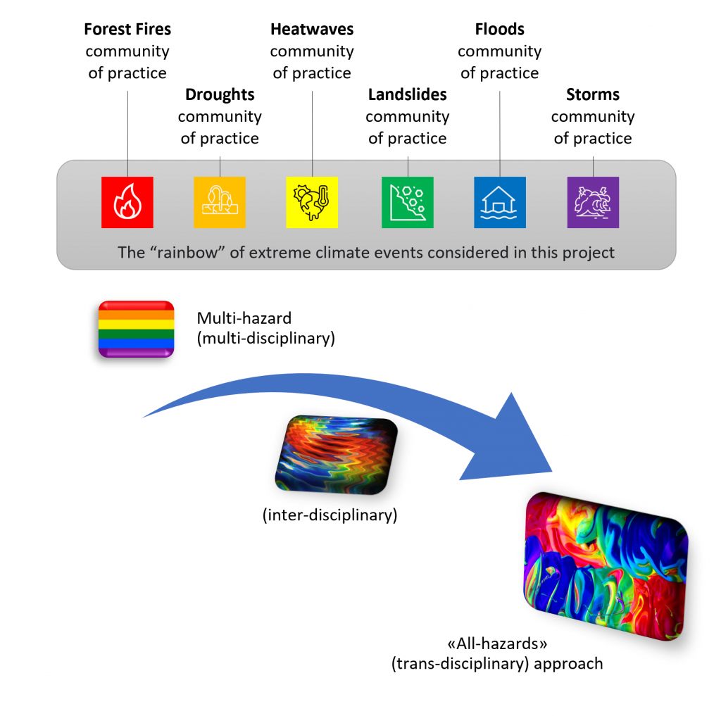
The PhD research will be conducted as part of a recently funded Horizon Europe project, coordinated by Prof. Michele Calvello, called “The HuT (Human-Tech nexus): Building a safe haven for coping with climate extremes.” The project includes 26 EU Partners and 10 demonstrators across Europe. The HuT will employ innovative DRR solutions, accounting for the potential variations induced by climate change, and will deal with weather-induced events tackled with trans-disciplinary risk management tools and approaches.
Deadline to apply for the PhD fellowship: 14 July 2022
Call:
https://web.unisa.it/en/teaching/phd-programmes
Annex:
https://web.unisa.it/uploads/rescue/151/6605/risk-and-sustainability-in-civil-architectural-and-environmental-engineering-systems.pdf
NEWS received from
Luca Piciullo (NGI Norway)
—–
First Workshop on Seismic noise and Geophysical monitoring for the IoT-based methods and analyses Working group
July 5, 2022 — 16:00 – 17:30 CET
Agenda
———-
Dr. Eric Larose is a CNRS Director of Research at Joseph Fourier University in Grenoble, France. Eric is the Director of LABCOM, a joint industry-academia research partnership focused on developing innovative technologies and methodologies to monitor and predict natural and artificial instabilities. Eric has a history of transdisciplinary work related to natural hazard monitoring. His expertise lies in geophysics and seismology.
Dr. Jim Whiteleyis a geophysicist, with expertise in integrating seismic investigation methods with well-established electrical resistivity tomography monitoring methods. His research focuses on the application of these methods to monitor landslides, with an emphasis on establishing hydrogeological and geomechanical precursors to slope failure. He is currently employed at the British Geological Survey.
Dr. Malgorzata Chmiel is Postdoc at Swiss Federal Institute for Forest, Snow and Landscape Research (WSL). She is a geophysicist, with expertise in seismic data (ground vibrations) generated by mass movements and ambient noise sources. Her research focuses the application of machine learning to natural hazards (e.g., debris flow detection with machine learning and seismic data).
NEWS received from
Mirianna Budimir (Practical Action, SHEAR)
Developing regional-scale landslide forecasting in two hazard-prone regions of India: the LANDSLIP project.
Over twelve per cent of the Indian land mass is prone to landslides, directly impacting settlements, roads, strategic trade corridors, and heritage sites. As part of the UKRI funded Science for Humanitarian Emergencies and Resilience (SHEAR) Programme, an international research team have co-developed a prototype regional-scale landslide forecasting system in two hazard-prone districts of India, helping authorities to improve early warning and build resilience to rainfall-triggered landslides. This research project, LANDSLIP “Landslide multi-hazard risk assessment, preparedness and early warning in South Asia: Integrating meteorology, landscape and society” research project, ran from 2016 to 2022.
The LANDSLIP consortium consisted of physical scientists, engineers, social scientists and practitioners from nine organisations in the UK, Italy, and India, including the Geological Survey of India, who are the principal government agency for landslides in India:
Through multi-agency collaboration, using interdisciplinary methodologies and perspectives and associated funding of eight PhD students, LANDSLIP has also developed new research and insights by building on existing scientific research in India, the UK and Italy.
Project outputs are aiding Indian authorities to further develop data, models, protocols and procedures to improve landslide forecasting and, in turn, support early warning.
For more information on the project, and to access resources produced by the project see:
NEWS received from
Graziella Devoli – NWE Norway
The LandAware WG7 – Operational LEWS is organizing three regional meetings to establish contact among members from the same country/region, to exchange experiences and to know about projects in the region and possibly to promote future collaborations among LandAware associates and observers. We would like to have the opportunity to discuss the status of landslide early warning systems in the region, needs, resources and limitations that delay or have delayed the organization of operational LEWS.
— — —
1. Meeting Latin America (in Spanish):
Wednesday 29th of June 2022 (at 8:00 AM Ciudad de Guatemala time, 16:00 CEST).
— —
2. Meeting Brazil (in Portuguese):
Monday 4th of July 2022 (at 18:00 Rio de Janeiro time, 23:00 CEST).
— —
3. Meeting Indian-Himalayan region (in English):
Wednesday 13 of July for India (18:00 Mumbai time, 14:30 CEST).
— —
Please forward this invitation to other colleagues that could be interested in this topic even if they are not part of the LandAware network.
For problem with the link, contact Graziella Devoli gde@nve.no
Best regards,
Graziella Devoli, Paulo Hader, Sesha Ammavajjala
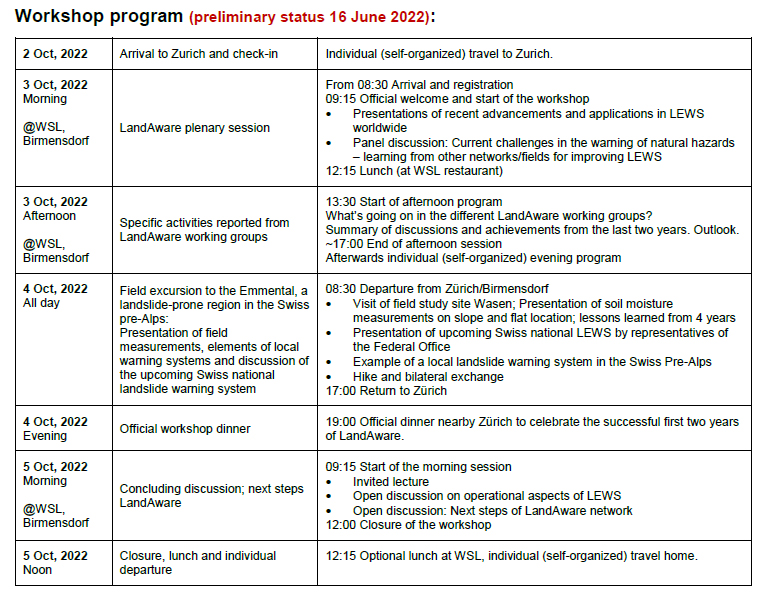
The preliminary program of the 2022 LandAware workshop, which will be held at the Swiss Federal Research Institute WSL in Birmensdorf, Zürich, Switzerland, on 3-5 October 2022, is online!